Maps and politics of (West) Vlandia
Revision as of 15:01, 9 April 2019 by Vordewindt (talk | contribs) (Vordewindt moved page Maps and politics of West Vlandia to Maps and politics of (West) Vlandia without leaving a redirect)
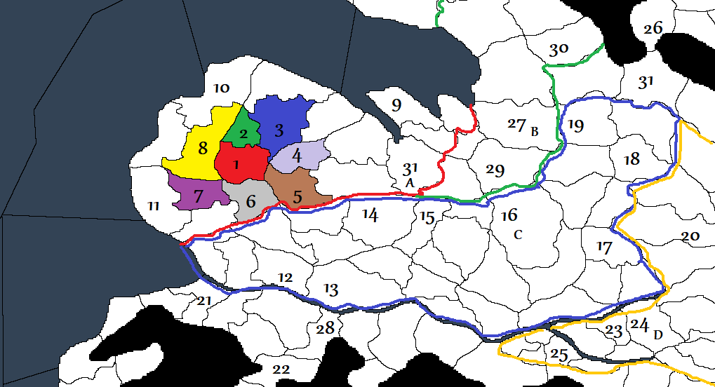
The political map of the Vlandian kingdom, highlighting West Vlandia
- Gastald of Krenn: Your in-game location. A wild region where you and your friends will be the first to live in. The area is split in two parts by the Esten river and offers a lot of free countryside where to settle and farm. Beware the southern forests and the hills though, they may be crowded with bandits!
- Seigneury of Hastig: A small hamlet managed by a man called Osegod, a jovial patriarch who took part in the war against the Empire.
- Seigneury of Brix: A thriving farmstead, they produce grain, turnips, cabbages and carrots.
- Abbey of Vermal: A place of culture, work and prayers. Abbot Bego is the monk at the head of the abbey and also the most prestigious character around the countryside. In the abbey the monks work tirelessly making books and potions.
- Seigneury of Lomel: A fishing village called Lomel on the river banks, the bailiff is called Ranuc.
- Seigneury of Darasio: A farming spot with few houses and a church.
- Gastald of Berghem: Here another Gastald holds a plot of land, they have a manor and they’re starting to build new houses and a small convent. The patriarch there is called Agelmund, of the Fara Letingi, another veteran of the war against the Empire.
- Gastald of Holm: A small outpost placed in the middle of the Esten forest, a ruthless captain rules there called Aicard “The Black” of the Fara Faroaldingi. More like a bandit hideout that is a place where it is better to not venture.
- Barony of Azgad
- Tevarin County and its city, Balanli
- Barony of Elberl
- Town of Nemeja
- County of Haringoth
- Town of Veidar
- Monastery of Lyindah
- Suno, capital of the Duchy of Suno
- Barony of Ruluns
- Ryibelet Hamlet
- County of Ryibelet
- Town of Ibiran
- Barony of Istiniar
- County of Maras
- Barony of Yaragar
- Uxkhal, capital of the Duchy of Uxkhal
- County of Vyincourd
- County of Jelbegi (part of the Duchy of Tihr)
- Harthar, capital of the Duchy of Arthar
- Barony of Meroc
- Bishopric of Remental
- Barony of Horsger
- Pravend, capital of the Vlandian Kingdom and of the Duchy of Pravend
- A - Duchy of Pravend - (red line)
- B - Duchy of Harthar - (green line)
- C - Duchy of Suno - (blue line)
- D - Duchy of Uxkhal - (yellow line)
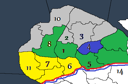
The political map of West Vlandia
- Grey - Territories of the County of Tevarin
- Yellow - Territories of the Barony of Elberl
- Green - Territories under the direct control of the Dux of Pravend
- Blue - Lands of the Vermal Abbey, “beneficium ecclesiae”. This land, even if part of the Vlandian Kingdom, has been given as “beneficium” to the Church. This means that the feudal lords have no authority within the borders of the land surrounding the Abbey.
Written by Wlodoviec

